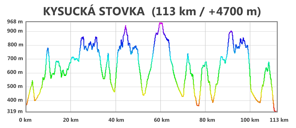
COURSE INFORMATION
Total distance: 113 km
Totak elevation gain: +4700 m
Online course map: LINK
GPX file for download: LINK
COURSE DESCRIPTION
After the presence (check-in in Kysucké Nové mesto sports hall) end we will walk together through Kysucké Nové Mesto and to the close village Radoľa, from which the following course begins:
TOURIST MAP VKÚ 110 Malá Fatra:
Green tourist mark: Radoľa (start) => kaplnka medzi Vretňami (country rad) => Snežnica => Zástranie =>
Amber tourist mark => Zástranie => Straník => Zástranie =>
Red tourist mark => Zástranie => Pod Kučerovkou => sedlo Žiarce (col) => sedlo Pod Zlieňom (col) => sedlo Nad Melišovcami (col) => Biely vrch => Pod Obelcom =>
Amber tourist mark => Skríželné =>
Own marking => Horný Vadičov, Kubaščíkovci =>
Green tourist mark => Skríželné => Povina => Jedľovina =>
TOURIST MAP VKÚ 101 Kysucké Beskydy, Veľká Rača:
Green tourist mark => Žihľavný Grúň => Nad Matúškovou =>
Red tourist mark => Černatín => Nad Matúškovou => sedlo Korcháň (col) => sedlo Rovne (col) =>
Amber tourist mark => Klubina =>
Own marking => follow the forest road to Úpratiská at Veľká Rača
Blue tourist mark => Chaty na Veľkej Rači =>
Green tourist mark => Pod Hladkou => Príslop =>
Amber tourist mark => Oščadnica, Dedovka =>
Own marking => Oščadnica, square =>
Amber tourist mark => Hrebeň Surovina (ridge) =>
Blue tourist mark => Oščadnica, píla => Oščadnica, railway station => osada Kýčera (small village) =>
Green tourist mark => Čadca (town) =>
Red tourist mark => Husárik =>
TOURIST MAP VKÚ 109 Javorníky, Čadca:
Red tourist mark => Chotárny kopec => Petránky including the outlook tower at Marťákovský kopec (hill) =>
Blue tourist mark => Vrchrieka nad Petránkami => Mičekovci
Amber toursit mark => Nesluša, Horná škola (school)
Own marking = > go through the village Nesluša =>
Green tourist mark => osada Majtánky (small village)
Blue tourist mark => Tábor => Kysucké Nové Mesto (finish in municipal sports hall)